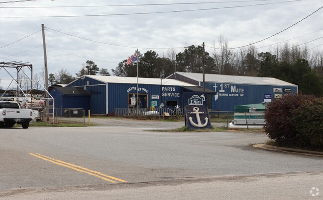
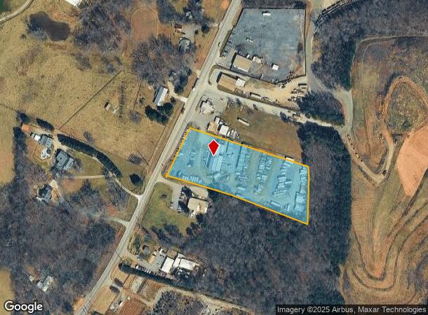
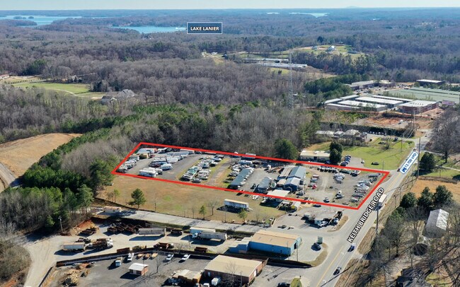
Property Record
4500 Keith Bridge Rd, Cumming, GA 30041
NEARBY LISTINGS FOR SALE OR LEASE
Property Detail
4500 Keith Bridge Rd
Atlanta-Sandy Springs-Roswell, GA
Cecil Bennett
254-015
14-1 575
Commercialnec
Forsyth
X
Georgia
13117C0070G
1,2
2024
3.58 AC
2025
N Fulton/Forsyth Cnty
130102
Atlanta
1,630 SF
DEMOGRAPHICS near 4500 Keith Bridge Rd
1 Mile
3 Mile
5 Mile
2024 Total Population
943
19,643
55,233
2029 Population
1,101
22,806
64,909
Pop Growth 2024-2029
+ 16.76%
+ 16.10%
+ 17.52%
Average Age
39
39
40
2024 Total Households
306
6,626
19,296
HH Growth 2024-2029
+ 16.67%
+ 16.18%
+ 17.65%
Median Household Inc
$83,173
$101,575
$101,147
Avg Household Size
3.10
2.90
2.80
2024 Avg HH Vehicles
2.00
2.00
2.00
Median Home Value
$489,705
$375,917
$389,811
Median Year Built
2001
2003
2001
Nearby Places
Map Layers
Map Styles
 Street
 Aerial
- Restaurants
- Banks
- Shops
- Fitness
- Groceries
SALE & LEASE HISTORY
LISTING DATE
SALE/LEASE

Mar 19, 2024
For Sale
Dec 03, 2019
For Sale
Nearby Properties
Address
Land Use
TOTAL SIZE
Lot Size
Zoning
Address
Land Use
TOTAL SIZE
Lot Size
Zoning
57,180 SF
61.71 AC
RES6
Address
Land Use
TOTAL SIZE
Lot Size
Zoning
28.74 AC
MP
Address
Land Use
TOTAL SIZE
Lot Size
Zoning
250,371 SF
88.47 AC
A1
Address
Land Use
TOTAL SIZE
Lot Size
Zoning
98,743 SF
12.61 AC
CBD
Address
Land Use
TOTAL SIZE
Lot Size
Zoning
50,875 SF
420.29 AC
A1
Address
Land Use
TOTAL SIZE
Lot Size
Zoning
19.21 AC
M1
Address
Land Use
TOTAL SIZE
Lot Size
Zoning
152,668 SF
41.92 AC
CBD
Address
Land Use
TOTAL SIZE
Lot Size
Zoning
59,534 SF
16.93 AC
CBD
Address
Land Use
TOTAL SIZE
Lot Size
Zoning
74,796 SF
9.92 AC
CBD
Address
Land Use
TOTAL SIZE
Lot Size
Zoning
192,550 SF
21.11 AC
CBD
Address
Land Use
TOTAL SIZE
Lot Size
Zoning
181,442 SF
32.34 AC
A1
Address
Land Use
TOTAL SIZE
Lot Size
Zoning
80,956 SF
6.07 AC
CBD
Address
Land Use
TOTAL SIZE
Lot Size
Zoning
375 SF
154 AC
LR
Address
Land Use
TOTAL SIZE
Lot Size
Zoning
229.24 AC
M1
Address
Land Use
TOTAL SIZE
Lot Size
Zoning
80,497 SF
9.22 AC
CBD
Address
Land Use
TOTAL SIZE
Lot Size
Zoning
12,217 SF
3.85 AC
CBD
Address
Land Use
TOTAL SIZE
Lot Size
Zoning
13.25 AC
CBD
Address
Land Use
TOTAL SIZE
Lot Size
Zoning
39,251 SF
109.39 AC
A1
Address
Land Use
TOTAL SIZE
Lot Size
Zoning
54,186 SF
26.64 AC
CBD
Address
Land Use
TOTAL SIZE
Lot Size
Zoning
54,090 SF
8.70 AC
CBD
Address
Land Use
TOTAL SIZE
Lot Size
Zoning
69,200 SF
5.61 AC
CBD
Address
Land Use
TOTAL SIZE
Lot Size
Zoning
2,955 SF
5.88 AC
NS
Address
Land Use
TOTAL SIZE
Lot Size
Zoning
33,608 SF
3.34 AC
HB
Address
Land Use
TOTAL SIZE
Lot Size
Zoning
40,092 SF
3.35 AC
M1
Address
Land Use
TOTAL SIZE
Lot Size
Zoning
3,060 SF
8.47 AC
M1
Address
Land Use
TOTAL SIZE
Lot Size
Zoning
1,595 SF
16.76 AC
CBD
Address
Land Use
TOTAL SIZE
Lot Size
Zoning
47,205 SF
40.23 AC
A1
Address
Land Use
TOTAL SIZE
Lot Size
Zoning
47,453 SF
6.87 AC
CBD
Address
Land Use
TOTAL SIZE
Lot Size
Zoning
31,423 SF
4.30 AC
CBD
Address
Land Use
TOTAL SIZE
Lot Size
Zoning
46,540 SF
11.10 AC
CBD
The World's #1 Commercial Real Estate Marketplace
Connect with us
© 2025 CoStar Group
The information above has been obtained from sources believed reliable. While we do not doubt its accuracy we have not verified it and make no guarantee, warranty or representation about it. It is your responsibility to independently confirm its accuracy and completeness. Any projections, opinions, assumptions, or estimates used are for example only and do not represent the current or future performance of the property. The value of this transaction to you depends on tax and other factors which should be evaluated by your tax, financial, and legal advisors. You and your advisors should conduct a careful, independent investigation of the property to determine to your satisfaction the suitability of the property for your needs.